

Planning Division
The Planning Division maintains and implements the City’s General Plan, Zoning Ordinance and prepares other specialized planning documents, including Specific Plans. The Division reviews development requests for conformance with the City’s planning policies and standards, and conducts environmental review under the provisions of the California Environmental Quality Act (CEQA). The Planning Division also monitors and analyzes regional planning issues to determine their impact to the City. The division provides staff support to the Planning Commission and City Council through the processing of rezoning, subdivisions, site plan reviews, use permits, variances, and other entitlements.
Address
125 E. College Street
Covina, CA 91723
Planning Counter Hours
Monday – Thursday
City Hall is Closed Fridays
7:00 AM – 1:00 PM
1:00 PM – 2:00 PM Closed (lunch)
2:00 PM – 5:45 PM
Covina Planning Division
A Division of the Community Development Department
The Planning Division maintains the City’s comprehensive General Plan, which serves as the legal guide for all development in the community, and advises the City Council, City Manager and Planning Commission on issues involving the future development of the community.
- Advise residents, property owners and developers on the use of real property
- Review proposals to develop, remodel or alter buildings, parking lots or other man made structures and ensure compliance with applicable zoning standards and design guidelines.
- Maintain records and statistics on the population and demographics of the City.
- Review the potential environmental consequences of public and private actions pursuant to the California Environmental Quality Act.
- Administer the Historic Preservation Ordinance and Plan.
- Process requests to annex property into the City of Covina.
- Provision of information and interpretation of the various federal, state, and local land use regulations.
- Preparation and distribution of handouts and maps showing City Streets, zoning, demographics, development standards, and other information.
Accessory Dwelling Units (ADU)
Frequently Asked Questions
IMPORTANT: Before applying, please verify the project address jurisdiction to determine if Covina is the appropriate agency to process your request. Any Covina address that is within “LA County” Jurisdiction must submit directly to the Los Angeles County Department of Regional Planning.
Yes. All accessory dwelling units require a covenant agreement, per Ordinance No. 22-06, passed, approved, and adopted May 17, 2022.
Per ADU Ordinance No. 22-06, ADUs greater than 800 square feet shall comply with newly adopted ADU design standards. Refer to Covina Municipal Code Section 17.69.040. The accessory dwelling unit shall provide complete and independent living facilities.If there is an existing primary dwelling, the total floor area of an attached ADU shall not exceed 50% of the existing primary dwelling. For detached ADUs, the total floor area shall not exceed 1,000 square feet.
- JADUs are units limited to 500 square feet in size that are contained within the walls of an existing or proposed single-family residence. One JADU is allowed on a lot with a proposed or existing single-family home.
- A JADU must have a separate entrance from the main entrance of the residence, and must include an efficient kitchen with cooking appliances and a small food preparation and storage area.
- In contrast to ADUs, owner occupancy of the JADU or the primary dwelling is required, unless the owner is a government agency, land trust, or housing organization.
- A deed restriction must be recorded to prohibit separate conveyance and restrict the size and attributes of the JADU.
- No additional parking is required for a JADU.
- An efficiency unit is one not less than 220 square feet in size.
Maximum building height shall not exceed 16 feet in height when it is located at least 4 feet from a side and rear property line. ADUs greater than 16 feet in height, (i.e. detached two story ADUs, a second-story ADU above a garage, the addition of a second-story ADU to an existing single-story residence, the addition of an attached two-story ADU to the primary residence, or any combination thereof) shall be permitted within the primary residence “buildable area,” as determined under CMC Sections 17.14 and 17.26 residential development standards. Single-story accessory dwelling units shall meet all the minimum 4-foot side and rear yard setback requirement. Accessory dwelling units within existing structures are not subject to additional building setbacks.
When a garage, carport, or covered parking structure is converted or demolished to construct an ADU, replacement parking of the lost off-street parking is no longer required.Other development standards, such as limits on lot coverage, floor area ratio, or open space requirements, cannot be applied to the extent they would prohibit an ADU that is at least 800 square feet and 16 feet tall, with a 4-foot rear and side yard setback.
A detached ADU may be combined with a Junior Accessory Dwelling Unit (JADU) that complies with the requirements described above, such that two additional units (one detached and one attached) are allowed on the lot. Given the size limitations, this means that a property could have a 500-square-foot JADU attached to the house and an up to an 800-square foot detached ADU.
Detached ADU sited within four to one or greater slopes, whether upslope or downslope, or within a High to Very High Fire Hazard Severity Zone (FHSZ) designation from Los Angeles County Fire Department, shall meet the following requirements:
- May encroach into the four to one ( 4: 1) or greater slopes by a maximum distance of 6 feet;
- Require Planning review and Los Angeles County Fire Department Review;
- Provide a minimum 10-foot fire defensive zone around the ADU (Defensible space is the buffer you create between a building on your property and the grass, trees, shrubs, or any wildland area that surround it. CALFIRE);
- Comply with construction requirements in the California Building Code and California Residential Code that are specific to the wildland-urban interface fire area.
- Roof material shall be tiles, slate or imitation thereof. Where the roof material for the main house consists of composition shingles, detached ADU can include the same material. If composition shingles are used, 40-year or higher grade architectural dimension shingles shall be used.
The first step is to submit your project to the Planning Division for review and approval. Any applications submitted to Building & Safety without a Planning Approval Clearance will be rejected and referred back to the Planning Division. “Building Permit Only” categories must still be submitted to Planning for verification of compliance before proceeding with Building & Safety.
Step 1: Review the Frequently Asked Questions Above and review the ADU Checklist
Step 2: Complete the ADU application form and assemble a submittal package as directed in the ADU application form. Need help determining what is needed on the plans? refer to sections 2 and 3 of the Site Plan Review handout.
Step 3: Submit items from Step 2 to Planning-Submittal@covinaca.gov or in person at the Planning counter (Mail is okay).
Please allow up to 15 days for planning staff to make a determination and to follow up with further instructions. For mail in option, allow up to 15 days after confirmation of receipt of package. If mailing your package, mail with attention to: Planning Division, City of Covina, 125 E College Stree, Covina, CA 91723.
Review the “conditions of Approval” section located on your Planning Approval Clearance document. As a requirement of submittal for building plan check, the Planning approval and the approved site plan, elevation, and floor plan shall be included as part of your submittal package. Typically these documents are located immediately after the title/cover page of the construction plans and are noted in the index on the cover page. See the steps below. Questions regarding Building Plan check can be inquired with the Building & Safety Division at 626-384-5460.
Submitting to Building & Safety for plan check:
Step 1: Review the Planning Approval Clearance provided to you by your case planner and integrate the Clearance and the stamped-approved site plan, floor plan, and elevations into construction plan set.
Step 2: Review the Building & Safety ADU Handout, Residential Submittal Checklist , and plan check process page.
Step 3: Prepare required documents according to Steps 1 and 2, and complete the Building Permit Application Form, complete the Address Request Form and provide either homeowner, contractor, or agent of contractor information.
Step 4: Submit prepared items in Step 3 to the Building Safety Division for Plan check.
* This page was last updated on August 4, 2022
* This page was last verified (reviewed) on November 7, 2022
Applications and Informational Handouts
IMPORTANT
Before applying, please verify the address to determine if Covina is the appropriate agency to process your request. If the address produces “County of Los Angeles” under Jurisdiction, please submit it directly to the Los Angeles County Department of Regional Planning.
NOTICE
**The last day to submit under the 2019 CMC/CRC is 12/22/20022. The package must be a complete submittal (Check with Building & Safety Requirements) and plan check fees MUST be pa id. Any incomplete submittals will be rejected and must be submitted under the 2022 CBC/CRC and follow all new codes referenced.
The Planning Division will accept hard copy submittals and submittals via email. For all email submittals, note the instructions below:
View the list below for applications, fees, informational handouts, and checklists.
Submit your application package to: Planning-submittal@covinaca.gov
Your application will be assigned to a case planner. Planning review time is approximately 15 to 30 working days from the date of submission. Email submittals shall always include, at a minimum:
- A PDF copy of a complete and signed application form;
- A site plan with a complete “project scope” description, identifying what is “existing” and what is “proposed;”
- A floor plan, both existing and proposed;
- Elevation plans, both existing and proposed;
- Roof Plan.
Please review the checklists to determine the items required for a complete submittal.
Most of our Application forms and Informational Handouts can be found below. More recent items such as SB-9 & ADUs have their own information pages.
Supporting Documents
- Application: Administrative Conditional Use Permit (ACUP)
- Application: ADU
- Application: Business License Zoning Clearance
- Application: Sidewalk Dining & Display
- Application: Sign Permit
- Application: SPR A,B,C,D
- Application: SPR E,F and SB-9
- Application: Temporary Banner
- Application: Temporary ACUP for Moving Pod
- Application: General/Zoning inquiry form
- Application: Historic Designation
- Application: Minor Variance
- Checklist: Conditional Use Permit
- Checklist: Administrative Conditional Use Permit (ACUP)
- Checklist: ADU
- Checklist: Lot Merger / Lot Line Adjustment
- Checklist: Model Home Sales Office
- Checklist: Pre-Application
- Checklist: Sidewalk Dining and Display
- Checklist: Sign Program
- Checklist: SPR A,B
- Checklist SPR C,D
- Checklist: SPR E, F
- Checklist: Tentative Parcel or Tract Maps
- Fees – Planning Review and Entitlement Fees
- Fees – Development Impact Fees
- Guidelines: Design Guidelines
- Guidelines: Trash enclosure specs
- Guidelines: Radius Map & Certified Property Owner Mailing List
- Guidelines: Street name sign standards
- Informational Handout: Building Official Information Guide
- Informational Handout: Business License Instructions
Planning Division Fee Schedule
ABC Investigation
ABC Investigation……….…………………….………………………………………………………..………………………………..….….……$100.00
Annexation
Annexation (City)…………………………….……………………………………………………………………….…….………..……..…..$14,463.00
Annexation (Community Facility District – CFD)………………..…………………………………………………………..… See Handout
Appeal
Appeal to Planning Commission or City Council………………………………………………………………….………..………..$3,800.00
(Applicant, Non-Applicant)
Business License Zoning Verification
Covina Business Licenses require a proper zoning “clearance” from the Planning Division that confirms the business activities are consistent with the Covina Zoning Code. Before applying for a Covina Business license, an applicant must first submit a BLZC Form to Planning@covinaca.gov and obtain a proper clearance from the division. The clearance should then be added to the Business License Application package.
Business License Review …………………………………………………………………………………………………………..……..…….. $122.00
Business license Review (with field check)………………………………………………………………………….….….………..….. $245.00
.
Conditional Use Permits (CUPs)
Administrative Conditional Use Permit (ACUP) – Category 1 (Events less than 30 days, Pumpkin Patch, Christmas Tree Lot, etc.)……. …………………………………………………………………………………..……… $450.00
Administrative Conditional Use Permit (ACUP) – Category 2 …………………………………………………………………….…………..… $650.00
Administrative Conditional Use Permit (ACUP) – Category 2 ………….………. $650.00
Administrative Conditional Use Permit (ACUP) – Category 3 (e.g. Carnival, Car Show, K-Run, Small Scale Auto Sales)….…. $2,541.00
Conditional Use Permit (New)……………………………………………………………………………………………………………$5,500.00
Conditional Use Permit (New) located within the Covina Town Center Specific Plan (CTCSP)…………………………$2,750.00
Conditional Use Permit Modification (Modification to an existing CUP)……………………………………………………………$2,750.00
6 Month CUP Compliance Review* …………..………………………………………………………………………………..………. $ 1,475.00
*In cases where a 6-month review for compliance is conditioned to a project. This fee covers public hearing notifications & staff time to revisit the Planning Commission within six months with a staff report summarizing the CUP’s operational activity and its compliance with the Conditions of Approval.
Development Impact Fees
Development Impact Fees are imposed on residential projects that result in new dwellings and nonresidential projects that result in new or additional square footage. The City’s development Impact Fee Schedule is based on the findings of the 2024 Development Impact Fee Nexus Study. The Development Impact Fee Schedule is adjusted annually in July of each calendar year, using the Construction Cost Index (CCI) for the Los Angeles Region as reported by Engineering News Record for the twelve months ending in May.
Development Impact Fee Public Information Handout
Effective July 1, 2025: FY 25/26 Development Impact Fee Schedule
General Plan Fee
The General Plan Fee is applied to Building Permits
General Plan Fee……………………………………………………………..……………… $2.50 per $1,000 of Construction Valuation
Hourly Rates and Inspections
Assistant Planner Hourly Rate……………………………………………………………………………….…………………………………$76.00
Associate Planner Hourly Rate…………………………………………………………………………..…..……………………..…………$84.00
City Planner (Manager) Hourly Rate………………………………………………………………………………………………….…………….………..$190.00
Community Development Director Hourly Rate………………………………………………………….………………..……….$279.00
Planning Aide Hourly Rate………………………………………………………………………………………………….……………………$32.00
Planning Technician Hourly Rate……………………………………………………………………………………………………………..$65.00
Senior Administrative Technician Hourly Rate…………………………………………………………………………….…………..$78.75
Re-Inspection Fee …………………………………………………………………………………………………………………………………$177.00
Additional Review ……………………………………………………………………………………………………………………………Actual Cost
Landscape & Construction Review Fee (L&C)
L&C: Artificial Turn Installation or Single-Family Construction………………………………………………………………$714.00
L&C: Project > 1 Acre………………………………………………………………………………………………………….………………..$980.00
L&C: Project 1.1 Acres to 2.99 Acres………………………………………………………………………………………………………$1,300.00
L&C: Project over 3 Acres……………………………………………………………………………………………………………………$2,900.00
Photocopies
Counter information…………………………………………………….……………………………………………………………..$0.10 per page
Filed Information………………………………………………………………………….$4.00 first page + $0.10 each additional page
Zone Maps Page…………………………………………………………………………………………………………………………………………$0.50
Large Book……………………………………………………………………………………………………………………………………………….$20.00
Small Book…………………………………………………………………………………………………………………………………………………$6.00
Planned Community Development (PCD)
Establishment of a PCD………………………………..………………….$14,463.00
Modification to an existing PCD……………………………………………………………………………..……….….………$5,571.00
Sign Permits and Programs
Sign Permit – Annual Display Program………………………………………………………………………….……………….………….$210.00
Sign Permit – Permanent…………………………………………………………………………………………….………………..……….….$590.00
Sign Permit – Temporary………………………………………………………………………………………………………………….…..……$345.00
Sign Program Review ……………………………………………………………………………………………………………………..………$1,900.00
Site Plan Review
Site Plan Review (SPR) Minor Applications under CMC 17.64.020(A) ……………………………………………………………$200.00
Site Plan Review (SPR) Minor Applications under CMC 17.64.020(B), except for SB35 projects and construction of an ADUs…………… ……………………………………………………………………………………………………………………………..………………….$2,200.00
Site Plan Review (SPR) Minor Applications under CMC 17.64.020(C) ………………………………………………………$8,900.00
Site Plan Review (SPR) for SB 35 projects and Multi-family projects over 10 units……………$8,900.00
Site Plan Review (SPR) Minor for ADUs that are 801 to 1,000 SF……………………………………………………………………….. $837.00
Site Plan Review (SPR) Minor for ADUs that are less than 800 SF (fee for preparation of Covenant Agreement)………. $200.00
Site Plan Review (SPR) Administrative Time Extension………………………………………………………………….. $590.00
Site Plan Review (SPR) Planning Commission Time Extension……………………………………………………….. $970.00
Special Reviews and Services
City Attorney Review of Covenants, Easements, or Other Legal Documents (Per Hour)…………..………..Contract Rate
Change in Nonconforming Use ……………………………………………………………………………………………………………….$5,500.00
Construction Plan Modification …………………………………………………………………………………………………….……….….$354.00
Construction Plan Review ………………………………………………………………………………………………………………………….$2,500.00
Designation of Historic Landmark/Structure of Merit (Private Applicant) ……………………………………………….$6,500.00
Environmental Impact Report – Staff Review and Consultant Costs …………………………………….Deposit + Actual Costs
General Plan Amend – Text or Map Change ………………………………………………………………………………….………Consultant Costs + 15%
Grading Plan Review ………………………………………………………………………………………………………….………………………$670.00
Lot Line Adjustment …………………………………………………………………………………………………………………………….…….$905.00
Outdoor Dining and Display – Less than six (6) seats (Director Review) …………………………………….$782.00
Outdoor Dining and Display – More than six (6) seats (Planning Commission Review) …………………………$2,500.00
Parking Agreement ……………………………………………………………………………………………………………………….…………$4,717.00
Shopping Cart Containment/Retrieval Plan Review ……………………………………………………………………….…………..$654.00
Special Construction Permit (Noise) ………………………………………………………………………………….……………………….$270.00
Special Plan Review (Lighting, CMD, Parking, etc.) ………………………………………………………………….………..………..$540.00
Staff Review of Applicant’s Initial Study, Environmental Reports, etc ………………….………$4,118 plus consultant costs
Tentative Parcel Map ………………………………………………………………………………………………………………………………$7,200.00
Tentative Tract Map ………………………………………………………………………………………………………………………………$11,830.00
Tentative Tract Map/Tentative Parcel Map: Minor Amendment or Time Extension …………………………………..$500.00
Vacation of Rights-of-Way …………………………………………………………………………………………………………………….…..$542.00
Verification & Research Fee ………………………………………………………………………………………………………………….Actual Cost
Zoning Ordinance Amend – Add Uses …………………………………………………………………………………………………….$5,500.00
Zoning Ordinance Amend – Text or Map Change ………………………………………………………………………………….$14,463.00
Zoning Verification Letter ……………………………………………………………………………………………………………………..…..$395.00
Tree Preservation
Designation of a Heritage Tree (Private Applicant)………………………………………………………………………………. $3,385.00
Tree Preservation Permit, Minor (one tree) …………………………………………………………………………………………………………. $1,377.00
Tree Preservation Permit, Regular (more than one tree) ………………………………………………………………………… $3,025.00
Variance
Minor Variance ……………………………………………………………………………………………………………………………………. $974.00
Major Variance (Single Family Residence) ………..………………………………………………………………………………….…$3,900.00
Major Variance (Non-Single Family Structure) ………………………………………………………………….……….………… $5,500.00
City Master Fee Schedule
This page’s primary focus is to provide information regarding applicable fees for development project entitlement/approval. After approval of development projects by the appropriate body (e.g., Administrative, Planning Commission, or City Council), development projects are subject to the City’s plan check, permitting, and inspection processes. The public may reference the City’s Master (User) Fee Schedule for fees associated with plan check, permitting, and inspection services (fees applicable post-development approval).
| Conditional Use Permits (CUPs) | Fees |
|---|---|
|
Administrative CUP: Special Event < 30 Days |
$105.00 |
|
Administrative CUP: Special Event (e.g. Carnival, Car Show, K-Run, Small Scale Auto Sales) |
$1,869.00 |
|
Administrative CUP: Bingo, Las Vegas Nights, etc |
$158.00 |
|
Administrative CUP: Fee for Non- Profits (No Charge with Verification of IRS Exempt Status) |
$320.00 |
|
Administrative CUP: Pumpkin Patch/ Christmas Tree Lot |
$225.00 |
|
CUP – New |
$4,134.00 |
|
$2,067.00 |
|
|
CUP – Modification to an existing CUP |
$2,067.00 |
|
CUP: 6-Month Review by Planning Commission |
$1,289.00 |
| ABC Investigation | Fees |
|---|---|
|
ABC Investigation without a CUP |
$105.00 |
|
ABC Investigation with CUP |
$105.00 |
| Annexation | Fees |
|---|---|
|
Annexation (City) |
$10,830.00 |
|
Annexation (Community Facility District – CFD) |
$4,500 |
| Appeal | Fees |
|---|---|
|
Appeal to Planning Commission or City Council: Other than SPR |
$1,699.00 |
|
Appeal to Planning Commission or City Council: Non-Applicant (SPR Only) |
$1,699.00 |
|
Appeal to Planning Commission or City Council: Applicant (SPR Only) |
$1,699.00 |
| Hourly Rates and inspection Fees | Fees |
|---|---|
|
Assistant Planner Hourly Rate |
$61.00 |
|
Associate Planner Hourly Rate |
$67.59 |
|
City Planner Hourly Rate |
$88.00 |
|
Community Development Director Hourly Rate |
$210.00 |
|
Planning Aide Hourly Rate |
$32.00 |
|
Planning Technician Hourly Rate |
$52.00 |
|
Senior Administrative Technician Hourly Rate |
$63.00 |
|
Re-inspection Fee |
$177.00 |
| Business License Zoning Verification | Fees |
|---|---|
|
Business License Review (In-Home & Other) |
$105.00 |
|
Business License Review (In-Home & Other) review and field |
$263.00 |
NOTICE: The City Council of the City of Covina Adopted (Resolution 2024-57) , adopting a Covina Development Impact Fee Nexus Study (2024), a Capital Improvement Program as part of the Nexus Study, and a newly revised Development Impact Fee Schedule. The Development Impact Fee Schedule shall become effective on September 16, 2024. The Newly adopted Development Impact Fee Schedule shall not be collected from projects that have, before the effective date of this Resolution, already received all required discretionary land use entitlements and permits from the City Council and/or Planning Commission to proceed with the development of the project. Development Impact Fees required for those developments before this date shall remain unchanged.
| Fees | Fees |
|---|---|
|
see handout |
|
|
General Plan Fee |
$2.00 per $1,000 of Construction Valuation |
| Landscape & Construction Review Fee (L&C) | Fees |
|---|---|
|
L&C: Artificial Turf Installation or Single-Family Construction |
$354.00 |
|
L&C: Project Less Than 1 Acre |
$620.00 |
|
L&C: Project 1.1 Acres to 2.99 Acres |
$886.00 |
|
L&C: Project Over 3 Acres |
$1,330.00 |
| Photocopies | Fees |
|---|---|
|
Counter information- Each Page |
$0.10 |
|
Filed Information |
First page $4.00 Each additional page $0.10 |
|
Zone Maps Page |
$0.50 |
|
Large Book |
$20.00 |
|
Small Book |
$6.00 |
| Planned Community Development (PCD) | Fees |
|---|---|
|
Establishment of PCD/Major Modification to PCD |
$10,830.00 |
|
Minor Modification to PCD |
$1,869.00 |
| Sign Permits and Sign Programs | Fees |
|---|---|
|
Sign Permit – Annual Display Program |
$210.00 |
|
Sign Permit – Permanent |
$316.00 |
|
Sign Permit – Temporary |
$105.00 |
|
Sign Program Review |
$1,128.00 |
| Site Plan Review (SPR) | Fees |
|---|---|
|
SPR Category A (Minor) |
$105.00 |
|
SPR Category B (Minor) |
$205.00 |
|
SPR Category C (Minor) |
$421.00 |
|
SPR Category D (Minor) |
$632.00 |
|
SPR Category E (Major) |
$3,168.00 |
|
SPR Categories E & F (Major) |
$5,417.00 |
|
Pre-application Review |
$632.00 |
|
SPR: Administrative Time Extension |
$266.00 |
|
SPR: Planning Commission Time Extension |
$812.00 |
|
Additional Review Fee |
Actual Cost |
| Special Reviews and Services | Fees |
|---|---|
|
Grading Plan Review |
$266.00 |
|
City Attorney Review of Covenants, Easements, or Other Legal Documents (Per Hour) |
Contract Rate |
|
Staff Review of Applicant’s Initial Study, Environmental Reports, etc |
$4,118 (Plus Consultant Costs) |
|
Environmental Impact Report – Staff Review and Consultant Costs |
Deposit + Actual Costs |
|
General Plan Amend – Text or Map Change |
$10,830.00 |
|
Change in Nonconforming Use |
$4,134.00 |
|
Construction Plan Modification |
$266.00 |
|
Construction Plan Review |
$266.00 |
|
Lot Line Adjustment |
$773.00 |
|
Outdoor Dining and Display |
$1,435.00 |
|
Parking Agreement |
$4,134.00 |
|
Designation of a Heritage Tree (Private Applicant) |
$5,970.00 |
|
Designation of Historic Landmark/Structure of Merit (Private Applicant) |
$5,970.00 |
|
Shopping Cart Containment/Retrieval Plan Review |
$654.00 |
|
Special Construction Permit (Noise) |
$177.00 |
|
Special Plan Review (Lighting, CMD, Parking, etc.) |
$266.00 |
|
Tentative Parcel Map |
$3,769.00 |
|
Tentative Tract Map |
$10,830.00 |
|
Tentative Tract Map/Tentative Parcel Map: Minor Amendment or Time Extension |
$500.00 |
|
Vacation of Rights-of-Way |
$450.00 |
|
Verification & Research Fee |
Actual Cost |
|
Zoning Ordinance Amend – Add Uses |
$4,736.00 |
|
Zoning Ordinance Amend – Text or Map Change |
$10,830.00 |
|
Zoning Verification Letter |
$316.00 |
| Tree Preservation | Fees |
|---|---|
|
Tree Preservation Permit, Minor |
$1,128.00 |
|
Tree Preservation Permit, Regular |
$2,504.00 |
| Variance | Fees |
|---|---|
|
Major Variance |
$4,134.00 |
|
Major Variance (Single Family Structure) |
$2,474.00 |
|
Minor Variance |
$1,236.00 |
Housing Element
City of Covina
2021-2029 Housing Element
Revised Draft September 2022
Virtual Community Meeting! The Community Development department hosted a virtual community meeting on Thursday, June 23rd to go over the DRAFT Housing Element and DRAFT Mixed-Use Overlay District.
If you would like to be notified of future meetings regarding the Housing Element, Please submit your contact information to City staff at (626) 384-5450 or by email to planning@covinaca.gov.
Supporting Documents
- Revised 6th Housing Element Public Review Draft (September 2022)
- Revised 6th Housing Element Public Review Draft (Appendix) (September
- 2022)Public Review Draft: Covina 6th Housing Element
- FAQ: Covina 5th Housing Element
- FAQ: Covina 6th Housing Element
- NOA: Public Review Draft Covina 6th Housing Element
- 5th Housing Element (Adopted 11/17/2020)
Landscaping Guidelines
In order to conserve water, the City of Covina encourages replacing your existing lawn with drought tolerant landscaping.
However, the City of Covina’s codes require that the entire front and street side yards (except approved driveways and walkways) must be landscaped with a live plant material. The key factor is that you have a complete ground cover. The County of Los Angeles has prepared guidelines to assist residents with planting drought tolerant landscaping. There are a variety of drought tolerant ground covers that will fill in the front yard to meet the City’s codes and achieve your goal to reduce water consumption. Some of the typical drought tolerant ground covers can include:
- Carmel Creeper (Ceanothus griseus horizontalis)
- Seaside Daisy (Erigeron glaucus)
- Silver Carpet (Dymondia margaretae)
- Trailing Ice Plant (Delosperma)
Of course, there are many other plants you may choose from. Please consult your nursery for additional options. Two things you want to keep in mind when planting a drought tolerant front yard: There should be no visible dirt or bark within 2 months of planting. This is typically achieved by planting ground cover plants close enough to fill in. Drought tolerant plants are not maintenance free. Be sure to keep them properly trimmed and free from weeds. Please remember if you add hardscape (cement, pavers, or similar) or a new sprinkler system you are required to obtain planning approval and/or a building permit. Good luck with your project!
Supporting Documents
Master Plans, Specific Plans, and General Plan
Hover over the hyperlinks to select one of our specific plans. Do not see what you are looking for? submit a public records request with the City clerk at Cityclerk@covinaca.gov
General Plan
The City of Covina’s General Plan documents are available for download here.
Covina Bicycle Master Plan
Covina Bowl Specific Plan
PCDs
Projects under Review
Mercy Lugo, Planning Manager – (626) 384-5450 Email preferred: mlugo@covinaca.gov
- 578 N. Azusa Avenue – 31,500 SF 3-Story Hotel (AVID Hotel). Under Review
- 1000 N. Azusa – Mixed Use Development of Old Albertson Site – Project on Hold
- 707 Barranca Avenue – ZEST 151-Unit Residential Development. Approved. Under Construction.
- 2040 E. Cienega Avenue – 12-Unit Multi-family Residential Development – Under Review
- 1330 E. Cypress Street – 189,312 SF 2-Story Self-Storage Facility (Public Storage). Scheduled for 9/27/22 PC Meeting. Final MND found under “Supporting Documents” below.
- 321 E. Front Street – Campsite Brewing – Bonefide Eating Establishment, Brew Pub & Micro-Brewery. Approved. Under Construction
- 1680 San Bernardino Road – Covina Bowl Mixed Use Development. Approved. Under Construction.
Reina Schaetzl – Associate Planning Consultant (Part-time). Office Hours: Mondays (7:00 – 6:00 PM) and Wednesdays (7:00 am to 3:00 PM). Phone No. (626) 384-5455
- 2003 E. Cienega Avenue – 25-Unit Detached Residential Condominium Development – Under Review
- 745-837 N. Dodsworth Avenue – 90,000 SF Concrete Tilt-up Industrial Building – New Submittal. Under Review.
- 200 N. Second Street – Christ First Church CUP Modification – Under Review
Nancy Fong, Community Development Consultant, Monday-Thursday 9:00 – 3:00 PM, (626) 384-546 Housing Element – Continued to September 27, 2022 PC Meeting.
- Mixed-Use Overlay Zone – Approved by Planning Commission September 13, 2022.
- Town Center Specific Plan Update – Adopted
- Meritage/Foothill Transit Specific Plan (Covina and Fairview Drive) – Covina Transit Oriented Mixed-Use Project. Redevelop the former K-Mart site with a mixed-use development consisting of the Covina Innovation, Technology and Event Center (iTEC), a Transit Center/Park & Ride facility, and a residential development – Approved
- Hassan Development – N/W Corner San Bernardino Rd & Citrus Ave – Approved
- City Ventures – NWC of Citrus Avenue and Orange Street – Approved
Joshua Periera, Planning Technician- (626) 384-5447
- 1909 Covina Boulevard – Zone Change from C-2 Commercial Zone (Neighborhood Shopping Center) to R-1 7500 Residential Zone (Single Family) – Scheduled for 9/27/22 PC Meeting.
- 144 N. Second Street – CUP22-03 and SPR 22-168 for an “Assembly Use (Sikh Temple) consisting of extensive exterior and interior building renovations. Under Review.
Claudia Vargas, Assistant Planner – (626) 384-5451
- 1201 W. Badillo Street – 43,604 SF 28-Unit 4-Story Residential Apartment Dev. Under Review.
- 345 S. Citrus Avenue – Used Car Dealership. Under Review.
- 472 E. Front Street – New 4,623 SF Industrial Building within the CTCSP “FAIR District”. Under Review.
| Title | Project Type | Project Status |
|---|---|---|
|
|
Land Use Under Review |
|
|
|
Land Use Approved and Under Construction |
|
|
|
Land Use Under Review |
|
|
|
Land Use Approved |
|
|
|
Land Use Approved and Under Construction |
|
|
|
Land Use Approved and Inactive |
|
|
|
Land Use Under Constitution |
|
|
|
Land Use Approved and Under Construction |
SB – 9 Two Unit Development
SENATE BILL 9 (SB 9)
On September 16, 2021, Governor Newsom signed SB 9 into law, which became effective January 1, 2022. Subject to certain requirements, SB 9 allows ministerial (staff level, without discretionary review or hearing) approval, within single-family residential zones, of a Two-Unit Development (proposed housing development containing no more than two (2) residential units (e.g., one duplex or two (2) detached single-family homes)) and an Urban Lot split (a subdivision of one (1) lot into two (2) lots).
In most circumstances, SB 9 will result in the potential creation of up to four dwelling units from an existing single-family parcel, generally displayed in the simplified scenarios depicted here.
WHAT IS THE PROCESS FOR SB 9?
Step 1: CONFIRM THE PROJECT IS ELIGIBLE
Projects for a Two-Unit Development and/or an Urban Lot Split must meet all the criteria on the respective Senate Bill (SB) 9 Eligibility Checklist to qualify for ministerial review. A project that includes a proposal for a Two-Unit Development and an Urban Lot Split must complete both
Eligibility Checklists.
IMPORTANT NOTE: SB 9 only applies to single-family residential zones. Please contact the Community Development Department-Planning Division to determine if your property is eligible.
Step 3: TIMELINES FOR MINISTERIAL REVIEW
- Completeness & Eligibility Review. The City will issue a determination of completeness and eligibility within 30 days of receipt of an application.
- Action on the Application. City staff will issue an approval or denial on the application within 60 days of the completeness determination.
Step 4: SUBMIT FOR BUILDING AND/OR ENGINEERING APPROVALS
Following project approval, an applicant may submit detailed construction plans to the Community Development Department-Building and Safety Division to obtain Building Permits, and Public Works-Engineering Division to obtain Encroachment Permits.
Step 2: SUBMIT A COMPLETE SB 9 APPLICATION PACKET
If you determine your project is eligible, you may apply for the SB 9 Two-Unit Development, and/or the Urban Lot Split using the Standard Application Form. In addition, the following forms are also required for a complete application.
- Standard Application
- Owner occupancy affidavit(for subdivision only)
- Prior tenancies affidavit
- Deed restriction for Two-Unit Development or
- Deed restriction for Urban Lot Split
ADDITIONAL INFORMATION REQUIRED:
Urban Lot Split. You will need to hire a Licensed Engineer to prepare a tentative parcel map and illustrate compliance with the Subdivision Map Act (Cal. Gov. Code, § 66410 et seq.) and Title 16, Subdivisions, of the Covina Municipal Code.
Two-Unit Development. You will need to hire a Licensed Architect or Builder Designer to prepare detailed site plan and building elevations to illustrate compliance with the applicable objective development and design standards of Urgency Ordinance 22-08.
NOTE: An ADU / Junior ADU is not permitted when the lot is split pursuant to SB 9.
SB 9 Frequently Asked Questions
Senate Bill (SB) 9 is a new law enacted by the State of California that increases the allowed density on certain single-family lots. SB 9 adds two new sections to the Government Code (§§ 65852.21 and 66411.7) that make it easier to add a second residential unit or split an existing lot (urban lot-split) in areas that meet the requirements.
SB 9 “urban lot-splits” are subject to the same restrictions as the two-unit project according to Government Code § 66411.7. If a parcel has some of these restrictions listed under Government Code § 66411.7, please meet with a planner to determine the applicability of SB 9. SB 9 requires that each resulting lot be at least 1,200 square feet. A parcel may only be subdivided using SB 9 one time (i.e., the 2 parcels resulting from the urban lot-split may not be further subdivided pursuant to SB 9).
Applicants for an urban lot-split under SB 9 must sign and record a deed restriction that they will use one of the units as their primary residence for a minimum of three years. Otherwise, units may be rented, but for terms longer than 30 days (no Short-Term Rentals).
SB 9 does not address rules or restrictions implemented and adopted by homeowners’ associations or included in CC&Rs (covenants, conditions, and restrictions). The City does not enforce private CC&Rs.
Senate Bill (SB) 8, also effective January 1, 2022, extends the requirements of the Permit Streamlining Act to housing projects of one unit or more that require no discretionary approvals. As a consequence, SB 9 projects are subject to the Permit Streamlining Act’s requirements for completeness determinations (within 30 days of submission) and approval deadlines (within 60 days of determining that the project is exempt from CEQA).
You may not demolish the dwelling if it is rent-controlled, subject to affordable housing restrictions, or a renter was evicted from the dwelling in the past 15 years. You may not demolish more than 25% of an existing dwelling’s exterior walls if the dwelling has been a rental property in the past 3 years.
When a lot split occurs, up to two units on each lot resulting from the lot split are allowed, inclusive of any primary dwelling unit, ADU, JADU, or SB 9 unit. When a lot split has not occurred, the lot is eligible to receive ADUs and/or Junior ADUs as it ordinarily would under ADU law, in addition to the primary dwelling unit and SB 9 unit. In no case will more than four units may be developed under either or both SB 9’s two-unit development and urban lot split authority. Additional information on requirements for ADUs can be found in Chapter 17.69 of the Covina Municipal Code.
Supporting Documents
SB – 9 Two Unit Development
Supporting Documents
- No. 1 Covina Town Square – SEC Azusa and Arrow
- No. 1A Ord. 12-2009 modified sign program for Covina Town Square
- No. 2 Palm Center – SEC 1000 Block N. Citrus Avenue
- No. 3 Citrus Plaza – NC 900 Block of Citrus Avenue
- No. 4 Covina Village Shopping Center – 501-621 N. Azusa
- No. 5 Covina Square – 100-400 N. Azusa & 800 San Bernardino Road
- No. 6 Professional Office (Assembly of God) – 302, 308, 316 San Bernardino Rd & 424 N. First Street
- No. 7 Berkeley Square – 900 E Badillo & 100 S Grand
- No. 7A Berkeley Square Sign Program amend – 980 E. Badillo
- No. 7B Berkeley Square Sign Program amend – 980 E. Badillo
- No. 8 Covina Commerce Center (Auto Uses & Storage) 1101 N. Azusa, North of Wash
- No. 9 Covina Market Place – 1400 N. Azusa Avenue
- No. 10 Covina Center – 902-908 E. Arrow Hwy near Grand Avenue
- No. 11 Arrow Hwy & Citrus Ave Shopping Center
- No. 13 Village Oaks Office Park – Garvey, Village Oaks, Center Court, Forest Hills, & Oak Park
- No. 14 Arrow Center – SEC Arrow_Hollenback
- No. 15 Commercial Building @ 143-159 E. Rowland
- No. 16 Terrado Plaza Financial Center – 750 Terrado Plaza
- No. 17 Covina Technology Center – 1325 -1411 N. Grand
- No. 18 Commercial Building – 426 N. Barranca Avenue
- No. 19 Walgreen’s Pharmacy – 401 N. Azusa Avenue
- No. 20 The Home Depot – 101 W. San Bernardino Road
- No. 21 Covina Center for the Performing Arts – 100, 104, 110, & 112 N. Citrus Avenue
- No. 22 Business Building – 125 S. Citrus Avenue
- No. 23 Commercial Office Building – 339-345 E. Rowland Street
- No. 24 Commercial Building – 1433 N. Hollenbeck
- No. 25 Plaza Commerical Center – 975-999 W San Bernardino
- No. 26 General Office Building – 300-308 W. Badillo Street
- No. 28 Citrus Walk – 302-328 N. Cirtus
- No. 29 Rancho Badillo Center – NWC Grand & Badillo
- No. 30 Popeyes & Retail Center – 525 S. Citrus Avenue
- No. 31 Emanate Health – 210 W San Bernaradino
- No. 32 Citrus Promenade (Meritage Homes) 1162 N Citrus
- No. 33 Atwood – SWC N Citrus_W San Bernardino (commericial_residential – City Ventures)
- No. 34 Circle K Sign Program – 731 N Grand Avenue (Conv. Store; Fuel Station; Carwash)
- No. 35 1054 Park View Drive, Sign Program (Oakmont)
- No. 36 IKEA Sign Program_SPR01-039
- No. 36 (Modification )
- No. 37 1477 N Azusa Ave (Pollo Campero Sign Program)
- No. 38 Citrus Town Center – 403-471 S. Citrus Avenue
Frequently Asked Questions
- Site plan (8.5×11), your site plan should show the entire property. & Elevations showing the height and materials. Elevations can be sectionals and must be called out on the site plan. (click here for sample)
- Minor application form.
- If the wall is a shared wall, a Property Owner Agreement form is also required.
Email all of the above requirements to Planning-submittal@covinaca.gov to drop off to the Planning Division
Historic Survey Report
Covina Town Center Historic Resource Survey
Prepared by Historic Resource Partners
Spring 2007
For the City of Covina
Mixed-Use Overlay District
The Mixed Use Overlay District (MUOD), consists of adding a new chapter of mixed-use overlay regulations to the City’s Zoning Ordinance and amending the City’s Official Zoning Map through the addition of a MUOD to various sites located located in Covina. the DRAFT MUOD spans 141 parcels within 13 project areas consisting of approximately 74.83 acres, excluding the Covina Town Center Specific Plan (CTCSP).
The proposed zone change does not take away any existing underlying commercial or industrial zones and would assume there is no net increase or additional commercial and industrial development, and no specific development project is proposed in connection with the MUOD at this time.
Why add a Mixed Use Overlay District?
Based on the Draft Housing Element (Also see our Housing Element tab), it was determined that there are insufficient sites to accommodate the City’s RHNA (Regional Housing Needs Assessment) allocation of 1,190 additional housing units for the current planning period.
State Law requires the City to amend its land use plans and regulations to create additional opportunities for housing development. If the City fails to amend land use plans and development regulations, then the City may be subject to State–imposed fines, sanctions and other penalties such as court imposed zoning amendment, freezing building permits, and court ordered housing project approvals.
Virtual Community Meeting
A virtual community meeting was held on June 23, 2022. Click Here for the informational flyer | Ver el folleto informativo en espanol
Initial Study/Mitigated Negative Declaration
The Covina Mixed Use Overlay District Initial Study/Mitigated Negative Declaration is available to review. Click here to obtain the document.
Supporting Documents
- Click Here for the full size Map
- DRAFT MUOD (June 9, 2022)
- DRAFT Mixed Use Overlay District ISMND
- DRAFT Mixed Use Overlay District ISMND – Appendices
- DRAFT MUOD (Study Session on February 2, 2022)
- Community Meeting on June 23, 2022!
- Sesión virtual el 23 de Junio, 2022!
- Covina MUOD Initial Study/ Mitigated Negative Declaration
- Mixed Use Overlay District Final MND
- Mixed Use Overlay District Final MND Appendices
Planning Commission
The Planning Commission of the City of Covina is established by State Government Code 65100 and is organized by Covina Municipal Code Section 2.28.010.
Planning Commission duties include the conduct of hearings relating to variances, conditional-used permits, zoning regulations, review of the General Plan, the conduct of studies, and other duties as required or authorized.
| Members | Term Expiration |
|---|---|
|
Rosie Richardson |
6/30/2024 |
|
Dan McMeekin |
6/30/2026 |
|
John Connors |
6/30/2026 |
|
Bryan Rodriguez |
6/30/2026 |
|
Jeanette Flores |
6/30/2028 |
Meetings take place on the Second and Fourth Tuesday of every month, at 7:00 PM within the Council Chambers of City Hall, unless otherwise noted on the Agenda. Agendas are posted on the City Website and the public display board located outside of City Hall on College Street the Thursday before the meeting date.
Residents or interested persons may attend in person at the time of the meeting. If you need special assistance to participate in a meeting, please notify the City Clerk’s office at 626.384.5430 or cityclerk@covinaca.gov. Notification of at least 48 hours enables the City to make reasonable arrangements for accessibility to the meetings. Interested persons may also view a live recording on Spectrum Channel 29, Frontier Channel 42, or on the City’s Website.
Meetings may be canceled if there are no items, or, adjourned if there is no quorum (at least three commissioners must be present, or a meeting cannot be held). In these cases, a “notice of cancellation” (Thursday Before the meeting) or a “Notice of Adjournment” (within 24 hours after the regular scheduled date) will be posted online, at the Council Chambers entrance, and on the City’s public display board.
Submit a request to Planning@covinaca.gov to be added to the notification list. In your request, please specify whether you would like to be notified of all agendas, or specific topics. Notifications are released the same day as the agenda packet.
Municipal Code Link
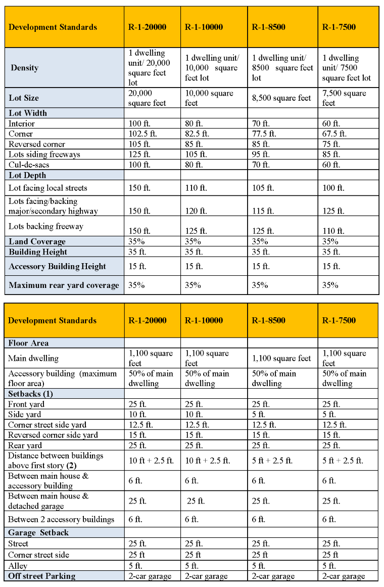
Residential Development Standards
The below tables with development standards are meant as a quick reference to the lot sizes, lot coverage, setbacks, building and structure heights. The property owners, applicants, architects and designers must check with all development standards and other regulations contained in Covina Municipal Code Title 17.
link to Municipal Code: https://www.codepublishing.com/CA/Covina/#!/Covina17/Covina17.html
Notes:
(1) See additional requirements for accessory buildings, patio covers, fence, walls, hedges, etc. under CMC Sections 17.26.050 through 17.26.210.
(2) Distance between buildings means between two adjacent main dwellings (houses).
For Multi-Family Development Standards, Click Here.
Click any thumbnail image to view a slideshow
Supporting documents
Tree Preservation (Oak Tree)
The City of Covina requires the preservation of mature trees to protect a valuable community resource. By preserving mature trees, we can improve the beauty, air quality, and property values of the community.
Preserving Mature Trees:
- Large mature trees provide habitat for wildlife and birds.
- They moderate the climate, improve air quality, and increase property value.
- Mature tees are also a historic resource.
Heritage Trees:
- Trees with a trunk diameter of at least 10 inches are protected as heritage trees.
- Trees of the following species are protected: Quercus (oaks)
- Trees designated by the city council as heritage trees are also protected.
Obtaining a Tree Preservation Permit:
- No person may damage a heritage tree without obtaining a permit.
- An application for a tree preservation permit must be submitted to the Chief Planning Official.
- The Application must include
- Name and address of the applicant and property owner.
- Evidence of ownership.
- Location of the property.
- A photograph of the tree(s).
- A site plan.
- A report from a certified arborist or licensed forester (may be waived for single-family residences)
- Mailing list and self-adhesive labels for properties within 300 feet of the subject property.
Fees for a Tree Preservation Permit:
- Tree Preservation Permit Minor: $1,128.00 (one tree)
- Tree Preservation Permit Regular: $2,205.00 (more than one tree)
Contact Us:
If you have any questions, please contact the planner on duty at (626) 384-5450.
- Minor Application Form
- Sample Plot Plan for Driveway Expansion and/or Landscape Coverage within the Front Yard Area
- Sample Plot Plan for Mechanical Equipment
- Sample Plot Plan for an Accessory Structure (Storage Shed)
- Sample Plot Plan for Total Lot and Rear Yard Coverage
- CMC 17.26.140(C)(1) and (C)(2) – Rear yard exceptions
- Encroachment Permit Handout – Public Works Department
- Grant Opportunity!